LIDAR is similar to radar technology, which uses radio waves, a form of electromagnetic radiation that is not in the visible spectrum. The range to an object is determined by measuring the time delay between transmission of a pulse and detection of the reflected signal. LIDAR technology has applications in Archaeology, Geography, Geology, Geomorphology, Seismology, remote sensing and many more areas.
Light detection and ranging (LIDAR), also known as airborne laser scanning (ALS), is an emerging remote sensing technology with promising potential to assisting mapping, monitoring, and assessment of forest resources. Compared to traditional analog or digital passive optical remote sensing, LIDAR offers tangible advantages, including nearly perfect registration of spatially distributed data and the ability to penetrate the vertical profile of a forest canopy and quantify its structure.
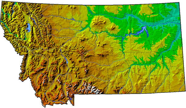
Applications of LIDAR range from archaeology, to atmospheric studies, bathymetry, etc. LIDAR has also found many applications in forestry. Canopy heights, biomass measurements, and leaf area can all be studied using airborne LIDAR systems. Similarly, LIDAR is also used by many industries, including Energy and Railroad, and the Department of Transportation as a faster way of surveying. Topographic maps can also be generated readily from LIDAR, including for recreational use such as in the production of orienteering maps.
Light detection and ranging (LIDAR), also known as airborne laser scanning (ALS), is an emerging remote sensing technology with promising potential to assisting mapping, monitoring, and assessment of forest resources. Compared to traditional analog or digital passive optical remote sensing, LIDAR offers tangible advantages, including nearly perfect registration of spatially distributed data and the ability to penetrate the vertical profile of a forest canopy and quantify its structure.
Applications of LIDAR range from archaeology, to atmospheric studies, bathymetry, etc. LIDAR has also found many applications in forestry. Canopy heights, biomass measurements, and leaf area can all be studied using airborne LIDAR systems. Similarly, LIDAR is also used by many industries, including Energy and Railroad, and the Department of Transportation as a faster way of surveying. Topographic maps can also be generated readily from LIDAR, including for recreational use such as in the production of orienteering maps.
Text Source: http://wiki.gis.com/wiki/index.php/LIDAR
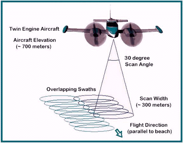
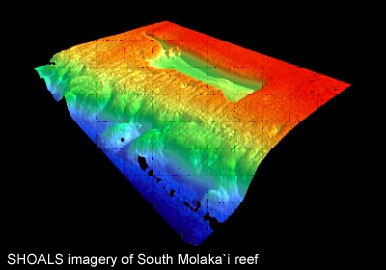
Image source: http://water.usgs.gov/osw/gps/GPS_projects.html
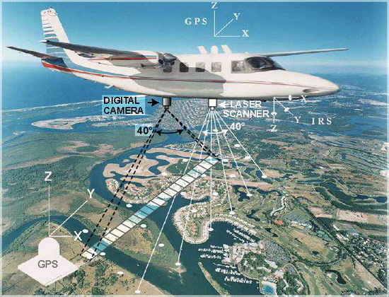
Image source: http://water.usgs.gov/osw/gps/GPS_projects.html
 RSS Feed